This website uses cookies to improve your experience. We\'ll assume you\'re ok with this, but you can opt-out if you wish. Read More
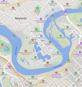
Welcome to the Maylands Historical and Peninsula Association’s Interactive Map.
The purpose of the Map is to enable local residents, visitors or persons interested in the history of our suburb to discover and learn about the many interesting places, people and buildings that exist in this fascinating suburb we call Maylands.
The Map consists of layers focussing on individual aspect of the suburb. To navigate the Map please select the layer that you are interested in. You can then hover over individual icons to read additional details on that item. To move to a different layer, deselect the one that you are in and then select the new layer.
Currently the available layers are:
- Heritage Buildings Walk
- Worshipful Maylands Walk
- Maylands Peninsula Walk
- Street Art Walk
- Houses and Streets of Maylands
- Maylands Aerodrome
- Our lovely Sponsors
- Maylands Border
- Maylands Shops and Businesses
The map is an ever-evolving project and if you would like to add your own information, or have any comments, please contact the Maylands Historical and Peninsula Association at maylandshs@gmail.com.